

Max Resource Obtains Historic Drilling Core from its New RT Gold Project in Peru


Vancouver B.C., December 21, 2020 – MAX RESOURCE CORP. (“Max” or the “Company”) (TSX.V: MXR; OTC: MXROF; Frankfurt: M1D2) is pleased to report historic drill core has been secured for the RT Gold project in Peru. Sixteen hundred metres of diamond drilling was completed on the Tablon gold-bearing massive sulfide in 2001.
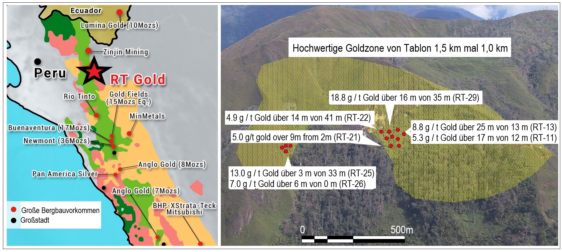
Highlight gold-rich drill intersections (refer to Figure 2 and Table 1 and 2):
- 18.8 g/t gold over 16-metres from 35-metres (RT-29)
- 13.0 g/t gold over 3-metres from 33-metre (RT-25)
- 8.8 g/t gold over 25-metres from 13-metres (RT-13)
- 7.0 g/t gold over 6-metres from 0-metres (RT-26)
- 5.3 g/t gold over 17-metres from 12-metres (RT-11)
- 5.0 g/t gold over 9-metres from 2-metres (RT-21)
- 4.9 g/t gold over 14-metres from 41-metres (RT-22)
- 3.1 g/t gold over 21-metres from 9-metres (RT-6)
Source: NI 43:101 Geological Report Rio Tabaconas Gold Project for Golden Alliance Resources Corp. by George Sivertz, Oct.3, 2011. Intervals are core lengths not true widths, which are unknown at this time.
“Management believes results like these are exceptional and rare. Whilst exploration is still at an early stage, the high-grades and thicknesses at shallow depths is remarkable,” commented Max CEO, Brett Matich.
“Expansion potential for Tablon is significant, and re-analysis of the historic core will guide selection of high priority drill targets,” he continued.
RT Gold, consisting of two contiguous mineral concessions located 760-km northwest of Lima, sits along the Condor mountain chain of northern Peru, within the Cajamarca metallogenic belt. This geological belt extends from central Peru into southern Ecuador, hosting a number of world-class gold deposits. The Company has exclusive rights to earn 100% of RT Gold. (refer to Figure 1).
The RT Gold project contains distinct mineralized systems: Cerro, a high-grade gold-bearing porphyry zone 2.0-km by 1.5-km; and Tablon, lying 3-km to the north west, a high-grade gold-bearing massive sulfide zone 1.5-km by 1.0-km.
The 2001 drilling of the Tablon zone consisted of 33 holes, ranging from 10.4 to 132.5-metres in length, and dipping from -45o to vertical, over a 400 by 200-metre area. High-grade gold values ranged from 3.1 to 118.1 g/t gold over core lengths ranging from 2.2 to 36.1-metres. In addition, hole RT-29 returned a metallics re-assay value of 186 g/t gold, indicating the presence of coarse gold.
Although multi-element analyses were completed on the drill core, only gold assays are available to the Company. Re-assaying will include the full multi-element suite with the objective of delineating high priority drilling targets.
“Exploration is advancing vigorously at the CESAR copper-silver project, where we anticipate initial results from the analysis of the recently obtained historic drill core, early in the new year,” Max CEO, concluded.

https://www.maxresource.com/images/news/MXR_GER_2020-12-21_Figure1.jpg
Figure 1. RT Gold location Figure 2. Tablon zone and highlight drill hole results
|
DDH Number
|
From (m) |
To (m) |
Length |
Gold g/t F. Assay |
RT-1 |
13.50 |
15.00 |
1.50 |
1.16 |
and |
24.00 |
25.50 |
1.50 |
4.59 |
RT-2 |
39.50 |
39.94 |
0.44 |
44.05 |
RT-3 |
62.18 |
62.85 |
0.67 |
49.99 |
and |
105.76 |
106.10 |
0.34 |
54.89 |
RT-4 |
7.85 |
11.90 |
4.05 |
2.23 |
and |
18.02 |
20.29 |
2.27 |
2.67 |
and |
26.29 |
28.42 |
2.13 |
2.61 |
RT-6 |
9.07 |
30.48 |
21.41 |
3.10 |
including |
9.07 |
15.24 |
6.17 |
5.48 |
RT-7 |
10.08 |
30.00 |
19.92 |
2.41 |
including |
10.08 |
12.55 |
2.47 |
4.55 |
and |
25.53 |
25.91 |
0.38 |
7.44 |
RT-11 |
12.01 |
29.10 |
17.09 |
5.32 |
including |
15.54 |
18.20 |
2.66 |
14.20 |
RT-12 |
17.41 |
21.76 |
4.35 |
4.71 |
RT-13 |
13.41 |
38.83 |
25.42 |
8.78 |
including |
19.85 |
22.75 |
2.90 |
19.81 |
including |
31.21 |
38.83 |
7.62 |
12.61 |
including |
33.72 |
34.72 |
1.00 |
28.24 |
RT-14 |
17.68 |
19.36 |
1.68 |
5.47 |
RT-15 |
12.80 |
19.20 |
6.40 |
5.85 |
RT-16 |
16.17 |
20.07 |
3.90 |
13.18 |
RT-21 |
1.52 |
10.97 |
9.45 |
5.08 |
RT-22 |
8.45 |
9.50 |
1.05 |
2.58 |
and |
31.39 |
33.80 |
2.40 |
3.21 |
and |
40.75 |
54.86 |
14.11 |
4.85 |
RT-25 |
33.00 |
36.1 |
3.1 |
12.97 |
including |
33.00 |
34.00 |
1.00 |
33.30 |
RT-26 |
0.00 |
6.00 |
6.00 |
6.95 |
including |
1.00 |
2.00 |
1.00 |
17.37 |
and |
12.02 |
13.00 |
0.98 |
2.80 |
and |
17.00 |
18.00 |
1.00 |
2.98 |
RT-27 |
9.76 |
12.00 |
2.24 |
1.49 |
and |
26.00 |
27.00 |
1.00 |
1.43 |
RT-28 |
1.52 |
10.54 |
9.02 |
1.93 |
and |
18.35 |
28.10 |
9.75 |
2.21 |
including |
23.34 |
25.71 |
2.37 |
5.99 |
RT-29 |
1.20 |
8.00 |
6.80 |
2.75 |
and |
34.85 |
51.25 |
16.40 |
17.99 |
including |
42.00 |
44.15 |
2.15 |
118.10 |
Table 1. Diamond Drill Hole (DDH) intersections and gold fire assay results. Source: NI 43:101 Geological Report Rio Tabaconas Gold Project for Golden Alliance Resources Corp. by George Sivertz, Oct.3, 2011. Intervals are core lengths not true widths, which are unknown at this time.
|
DDH Number
|
UTM E DATUM PSAD 56 |
UTM N Garmin 12 GPS Data |
Elevation Garmin 12 GPS Data |
Azimuth North is 360 |
Dip Horizontal is |
Length Measured From collar |
RT-1 |
706462 |
9418622 |
1918m |
355 |
-45 |
126.19 |
RT-2 |
706448 |
9418611 |
1916m |
355 |
-45 |
57.92m |
RT-3 |
706479 |
9418667 |
1955m |
340 |
-45 |
142.65m |
RT-4 |
706436 |
9418644 |
1948m |
147 |
-75 |
33.54m |
RT-6 |
706436 |
9418644 |
1948m |
127 |
-75 |
42.68m |
RT-7 |
706436 |
9418644 |
1948m |
115 |
-66 |
31.71m |
RT-11 |
706434 |
9418684 |
1985m |
310 |
-45 |
34.75m |
RT-12 |
706434 |
9418684 |
1985m |
310 |
-65 |
35.67m |
RT-13 |
706434 |
9418684 |
1985m |
280 |
-45 |
41.76m |
RT-14 |
706434 |
9418684 |
1985m |
280 |
-65 |
40.24m |
RT-15 |
706434 |
9418684 |
1985m |
344 |
-50 |
30.79m |
RT-16 |
706410 |
9418661 |
1976m |
310 |
-45 |
25.91m |
RT-21 |
706384 |
9418645 |
1976m |
- |
-90 |
24.4m |
RT-22 |
706353 |
9418697 |
2016m |
155 |
-45 |
69.21m |
RT-25 |
706144 |
9418499 |
2016m |
310 |
-45 |
39.94m |
RT-26 |
706144 |
9418499 |
2016m |
330 |
-45 |
33.53m |
RT-27 |
706144 |
9418518 |
2026m |
215 |
-45 |
45.73m |
RT-28 |
706397 |
9418691 |
1999m |
- |
-90 |
36.28m |
RT-29 |
706397 |
9418691 |
1999m |
180 |
-60 |
80.8m |
Table 2. Tablon DDH locations and statistics
CESAR COPPER-SILVER PROJECT - COLOMBIA
The CESAR project spans an area of ~500 sq.km in North Eastern Colombia, covering a major part of a 200-km long sediment-hosted copper-silver belt. The CESAR region enjoys major infrastructure as a result of oil & gas and mining operations, including Cerrejon, the largest coal mine in Latin America, jointly owned by global miners BHP Billiton, XStrata and Anglo American (refer to Figure 1).
Max has entered into three non-exclusive confidentiality agreements regarding the CESAR project: one with one of the world’s leading copper producers; a second with a global mining company and a third with a mid-tier copper explorer.
The exploration priorities for the CESAR project are: regional geochemical sampling, structural modelling interpretation of seismic data, analysis of oil & gas drill cores and expansion of landholdings.
Exploration activities on multiple fronts include:
- AM North: consisting of 29 sq.km of continuous copper-silver mineralization, open along strike and down dip, containing a high-grade area with varying intervals grading 4.0 to 34.4% copper + 28 to 305 g/t silver (July 29, 2020);
- AM South: occurring along the same stratabound mineralized trend, 40-km SSW of AM North, covering 16 sq.km, open laterally. Highlight values of 6.8% copper and 168 g/t silver from 0.1 to 25-metre intervals, suggest these horizons could be of significant size (October 7, 2020);
- CESAR South: a newly acquired 340 sq.km property, hosting stratabound copper-silver over at least 15-km of strike with highlight grab sample values of 11.4% copper + 656 g/t silver;
- Fathom Geophysics is currently interpreting new geophysical data funded by the Company in collaboration with one of the world's leading copper producers;
- Ongoing structural analysis and interpretation of seismic data is being conducted by Ingeniería Geológica Universidad Nacional de Colombia (“IGUN”) in Medellín, in conjunction with the Max team.
ABOUT MAX RESOURCE CORP.
Max Resource Corp. is advancing both its stratabound Kupferschiefer type CESAR copper-silver project in Colombia and the newly acquired RT Gold project in Peru. Both projects have potential for the discovery of large-scale copper and precious metals deposits.
Tim Henneberry, P Geo (British Columbia), a member of the Max Resource Advisory Board, is the Qualified Person who has reviewed and approved the technical content of this news release on behalf of the Company.
For more information visit: https://www.maxresource.com/
For additional information contact:
Max Resource Corp.
Tim McNulty
T: (604) 290-8100)
Neither TSX Venture Exchange nor its Regulation Services Provider (as that term is defined in the policies of the TSX Venture Exchange) accepts responsibility for the adequacy or accuracy of this release
Except for statements of historic fact, this news release contains certain "forward-looking information" within the meaning of applicable securities law. Forward-looking information is frequently characterized by words such as "plan", "expect", "project", "intend", "believe", "anticipate", "estimate" and other similar words, or statements that certain events or conditions "may" or "will" occur. Forward-looking statements are based on the opinions and estimates at the date the statements are made and are subject to a variety of risks and uncertainties and other factors that could cause actual events or results to differ materially from those anticipated in the forward-looking statements including, but not limited to delays or uncertainties with regulatory approvals, including that of the TSXV. There are uncertainties inherent in forward-looking information, including factors beyond the Company’s control. There are no assurances that the commercialization plans for Max Resources Corp. described in this news release will come into effect on the terms or time frame described herein. The Company undertakes no obligation to update forward-looking information if circumstances or management's estimates or opinions should change except as required by law. The reader is cautioned not to place undue reliance on forward-looking statements. Additional information identifying risks and uncertainties that could affect financial results is contained in the Company’s filings with Canadian securities regulators, which filings are available at www.sedar.com